
Οι καλύτεροι δρόμοι,
σχεδιασμένοι για σένα.
Φτιάχνουμε διαδρομές με τις στροφές που ψάχνεις, οργανώνεις ραντεβού με την παρέα σου και πλοηγείσαι με ειδοποιήσεις σε πραγματικό χρόνο. Όλα σε μία εφαρμογή, φτιαγμένη από μοτοσικλετιστές για μοτοσικλετιστές.
Δική μας τεχνολογία
Δεν νοικιάζουμε την τεχνολογία μας. Τη φτιάχνουμε.
Όσο οι άλλες εφαρμογές βασίζονται σε API τρίτων —και σου περνάνε τον λογαριασμό—, το MotoFlap τρέχει πάνω σε δική του υποδομή, σχεδιασμένη από τη δική μας ομάδα μηχανικών. Το αποτέλεσμα; Περισσότερες δωρεάν δυνατότητες και τιμή χωρίς ανταγωνισμό.
Δικός μας μηχανισμός διαδρομών
Υπολογίζουμε κάθε διαδρομή στους δικούς μας servers, βελτιστοποιημένους για τη χάραξη που πραγματικά θέλει ένας μοτοσικλετιστής: στροφές, ορεινά περάσματα και επαρχιακούς δρόμους.
Ενημερωμένη παγκόσμια χαρτογράφηση
Παγκόσμια χαρτογράφηση βασισμένη στο OpenStreetMap, φιλοξενούμενη και ενημερωμένη στη δική μας υποδομή. Χωρίς όρια χωρών και χωρίς τα όρια χρήσης τρίτων.
Οι διαδρομές σου είναι δικές σου
Δεν πουλάμε τη δραστηριότητά σου ούτε εξαρτιόμαστε από τη Google. Η τηλεμετρία σου ζει στα δικά μας συστήματα, όχι σε αυτά κάποιου διαφημιστή.
Servers στην Ευρώπη
Δική μας υποδομή υψηλών επιδόσεων στην Ευρώπη, παρακολουθούμενη ώστε να ανταποκρίνεται σε πραγματικό χρόνο, όπου κι αν βρίσκεσαι.
Όλα σε μία εφαρμογή
Φτιαγμένη για το πώς οδηγείς στ' αλήθεια
Σχεδίασε, μοιράσου και πλοηγήσου χωρίς να πηδάς ανάμεσα σε πέντε διαφορετικές εφαρμογές. Συγκεντρώνουμε στο MotoFlap όλα όσα χρειάζεται ένας μοτοσικλετιστής πριν, κατά τη διάρκεια και μετά από κάθε βόλτα.
Σχεδιασμός διαδρομών
Φτιάξε βελτιστοποιημένες διαδρομές για μηχανή μέσα σε δευτερόλεπτα. Ρύθμισε το επίπεδο στροφών, απόφυγε τους αυτοκινητόδρομους και κάνε εξαγωγή του track έτοιμο για τον πλοηγό σου.
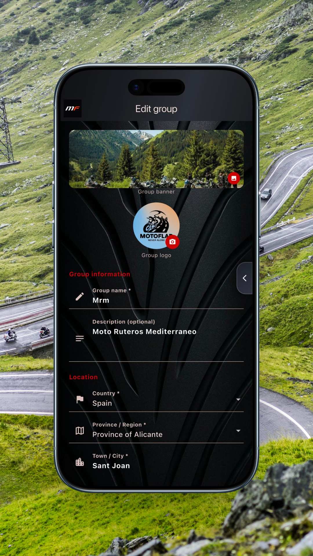
Ιδιωτικές ομάδες
Φτιάξε τη λέσχη ή την παρέα σου με μια ιδιωτική ομάδα. Διαχειρίσου τα μέλη, μοιράσου διαδρομές και οργάνωσε εξορμήσεις χωρίς φασαρία και χωρίς αγνώστους.
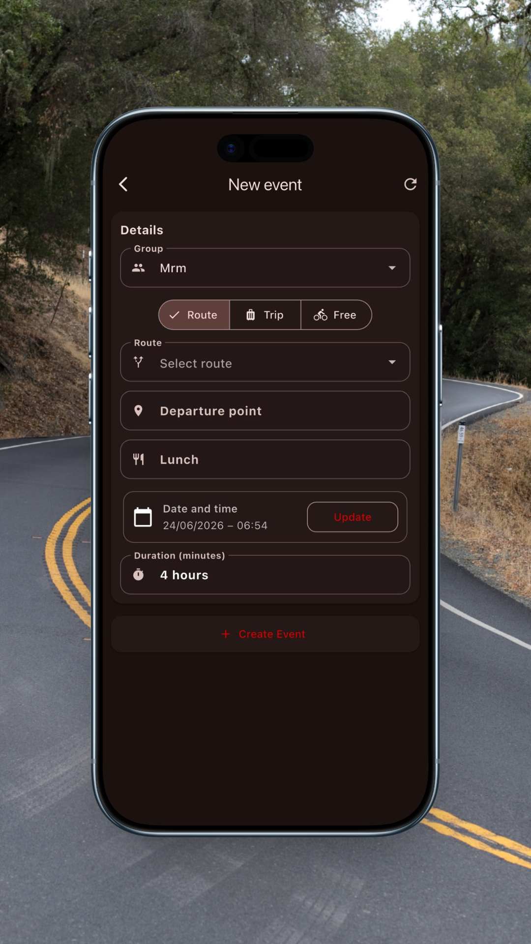
Εκδηλώσεις και συναντήσεις
Ανέβασε μια συνάντηση, επιβεβαίωσε ποιοι θα έρθουν και μοιράσου το σημείο εκκίνησης. Όλη η παρέα ξέρει πού και πότε, χωρίς ατελείωτα μηνύματα.
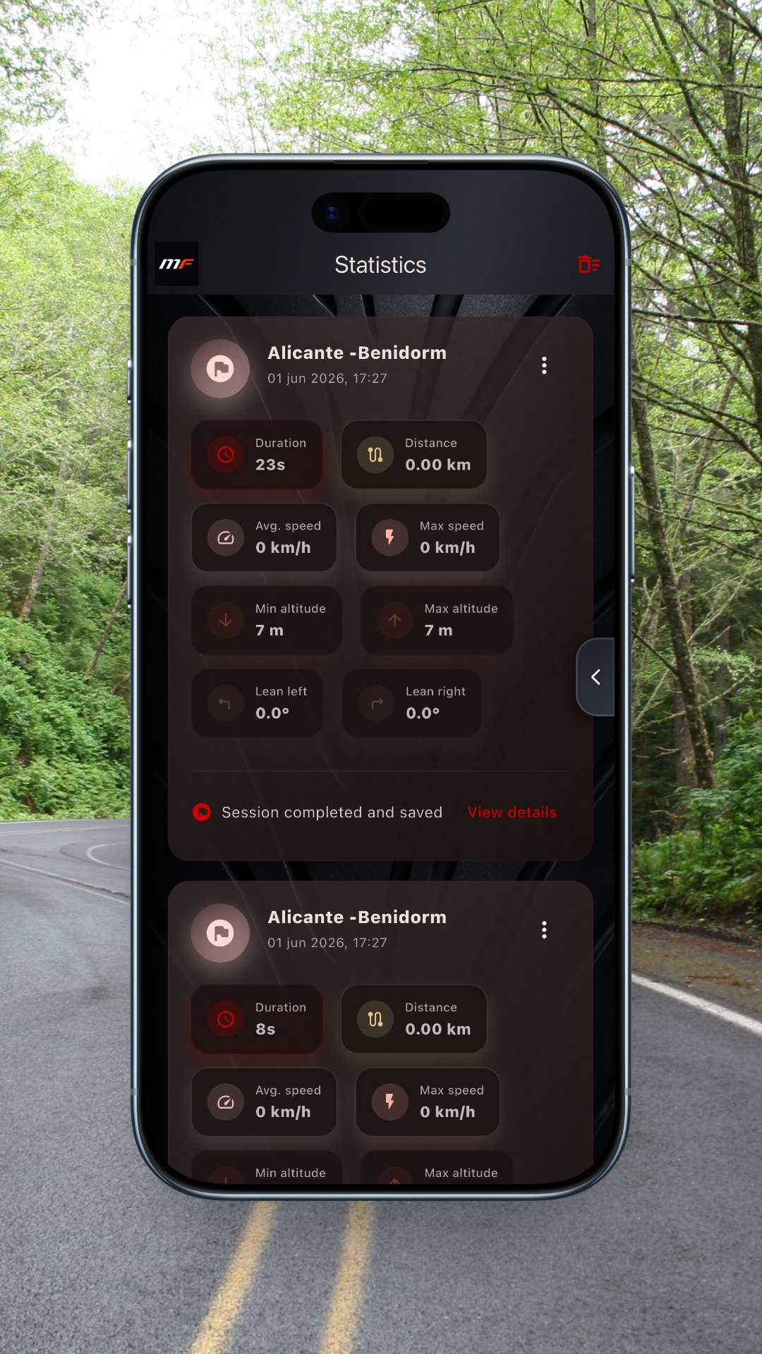
Στατιστικά
Κατέγραψε κάθε εξόρμηση και δες χιλιόμετρα, υψομετρική διαφορά και στροφές που μάζεψες. Η σεζόν σου με τη μηχανή, σε νούμερα.
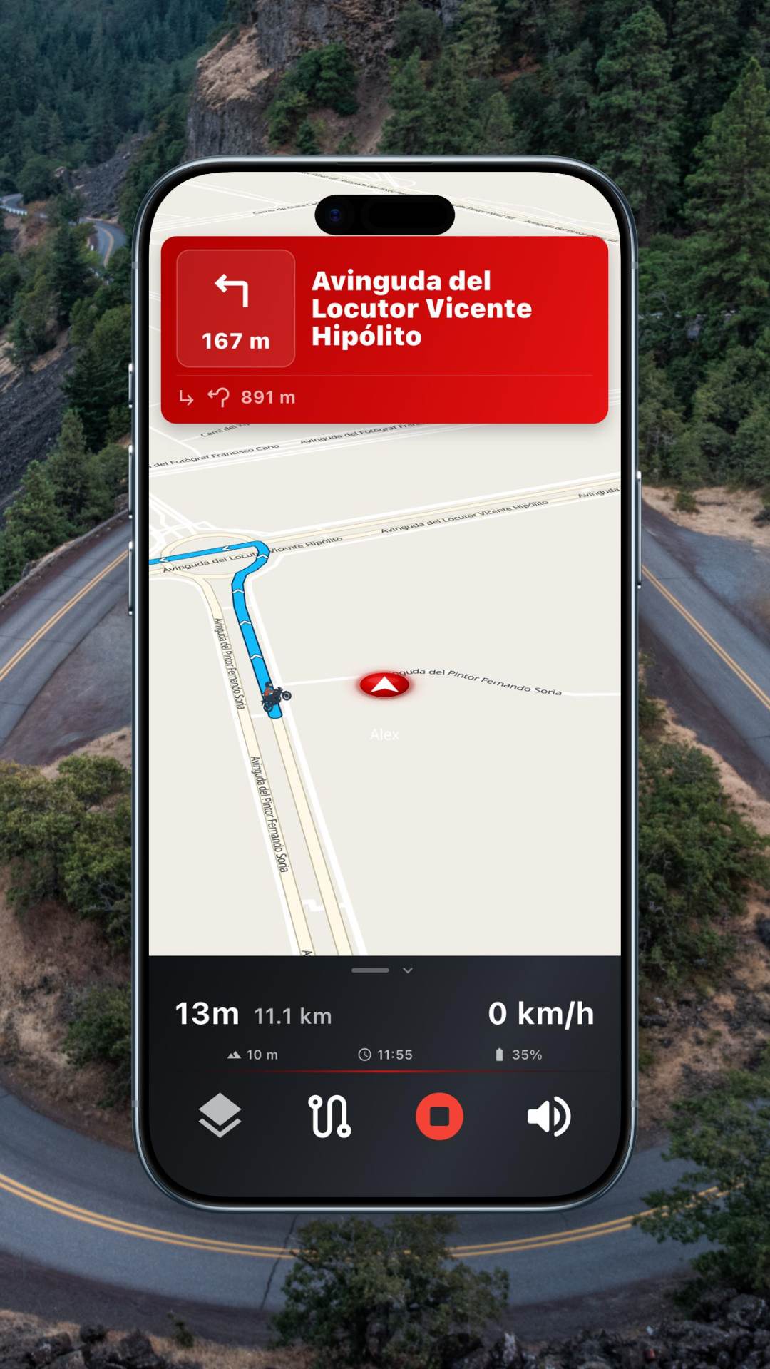
Πλοήγηση με ειδοποιήσεις
Πλοηγήσου με ειδοποιήσεις για κάμερες και καιρό στη διαδρομή. Συμβατό με βάση τιμονιού, Android Auto και CarPlay.
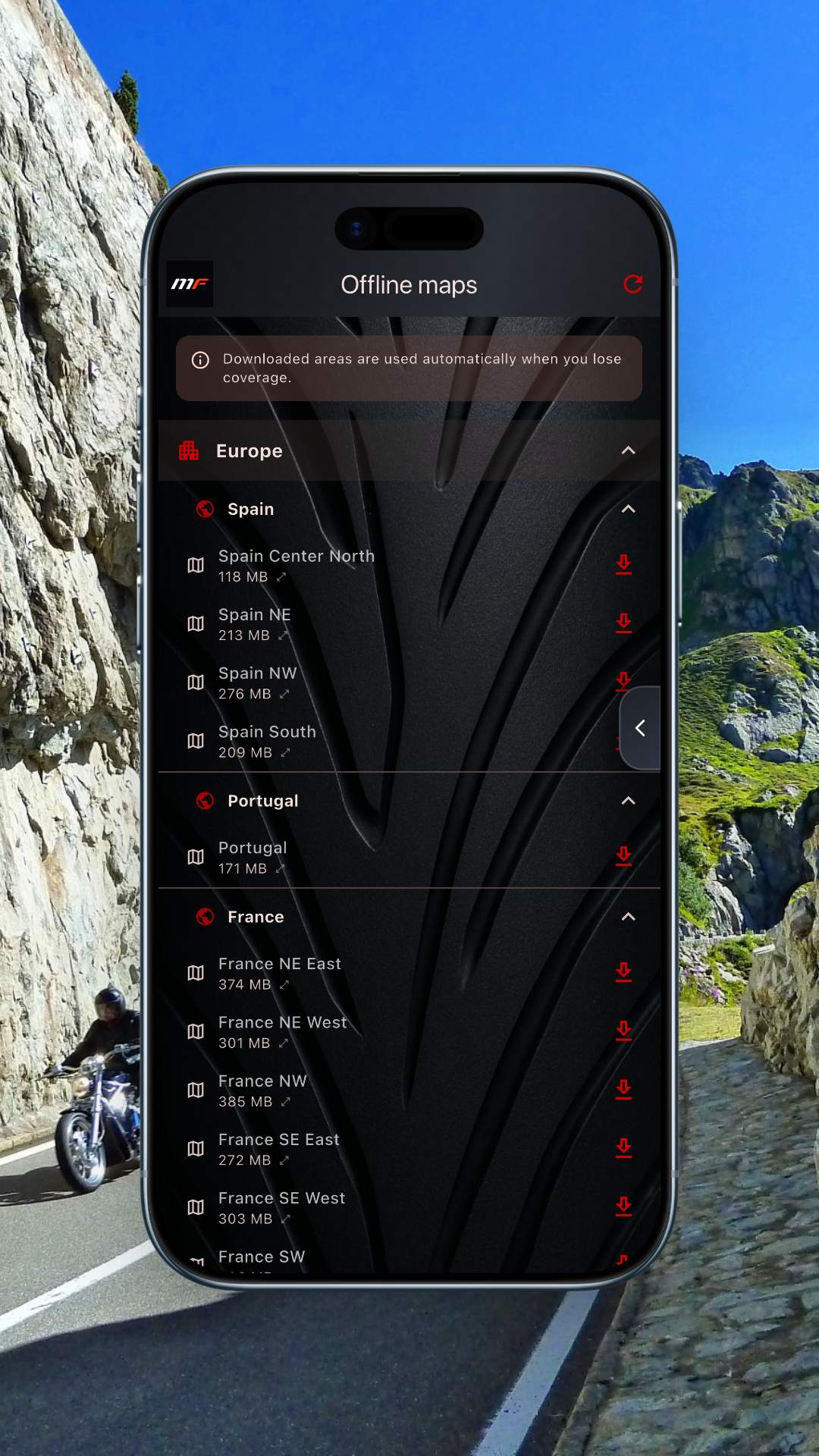
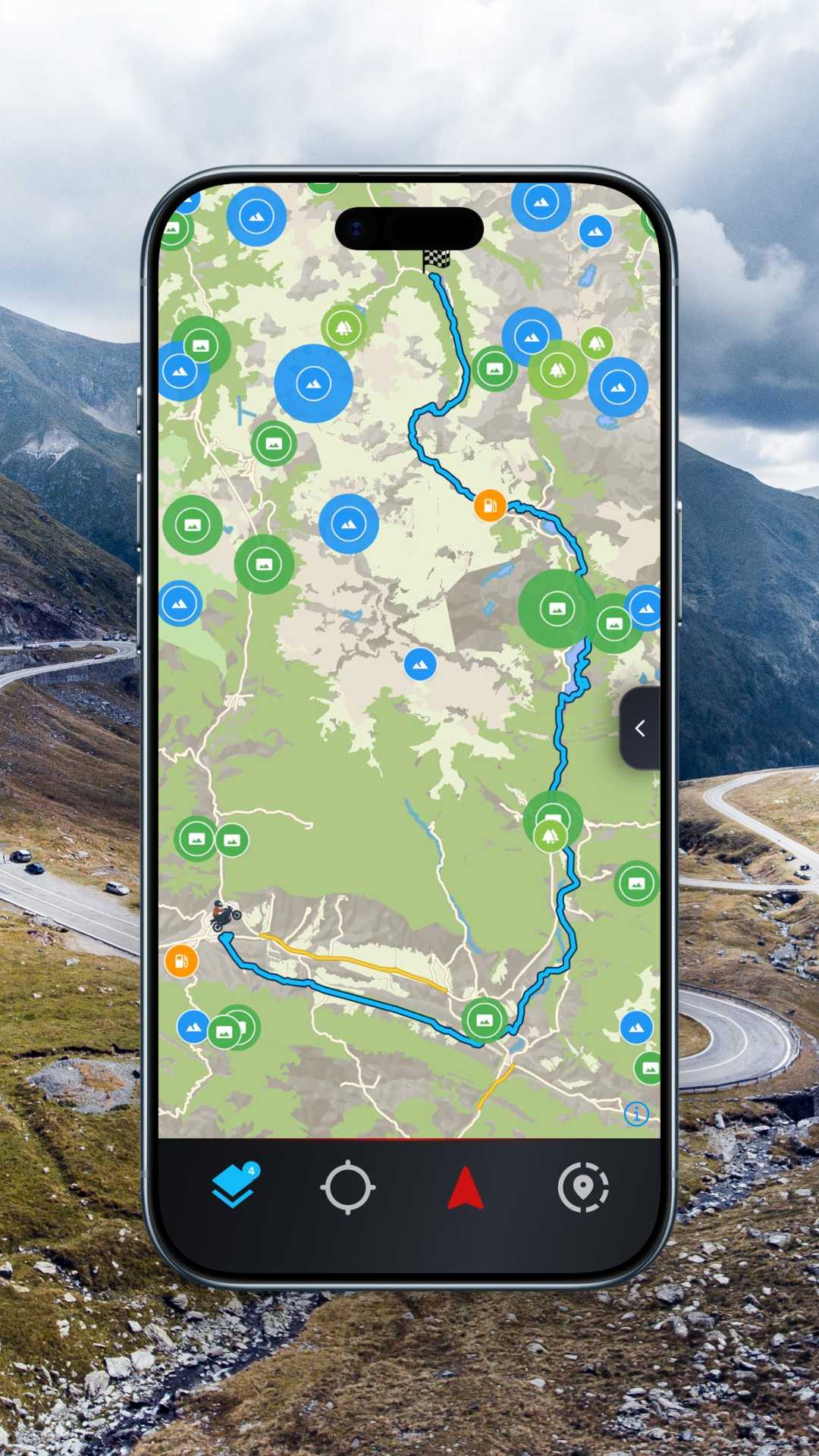
Offline χάρτες
Κατέβασε ολόκληρες περιοχές για να πλοηγείσαι χωρίς σήμα. Περιλαμβάνει 11 κατηγορίες POI για μοτοσικλετιστές: βενζινάδικα, ορεινά περάσματα, σημεία θέας, συνεργεία και άλλα.
Σχεδιασμένο για τα οικοσυστήματα που ήδη χρησιμοποιείς
Πλοηγήσου στην οθόνη της μηχανής σου
Το MotoFlap συνεργάζεται με το Apple CarPlay και το Android Auto. Σύνδεσε το κινητό στο ταμπλό ή στον πλοηγό της μηχανής σου και ακολούθησε τη διαδρομή σου με στροφές, ειδοποιήσεις και καιρό κατευθείαν στην οθόνη, χωρίς να αφήνεις το τιμόνι.
- Οδηγίες στροφή προς στροφή σε μεγάλη οθόνη
- Ειδοποιήσεις για κάμερες και καιρό μπροστά στα μάτια σου
- Έλεγχος με φωνή και κουμπιά τιμονιού
Ο σχεδιαστής
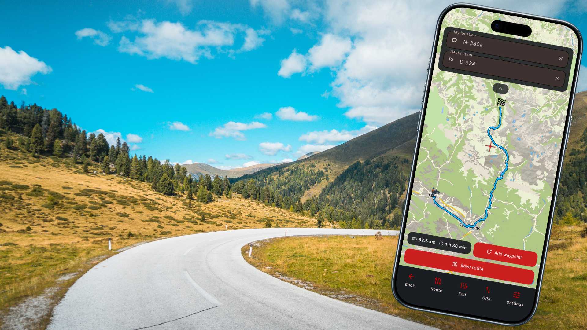
Από δύο σημεία στην καλύτερη διαδρομή σε δευτερόλεπτα
Πες μας πού θες να πας και πόσες στροφές έχεις όρεξη. Υπολογίζουμε τη χάραξη που πραγματικά θα απολαύσεις, όχι τη συντομότερη. Σύγκρινε επιλογές, ρύθμισέ τη και κάνε εξαγωγή.
Βάλε αφετηρία και προορισμό
Γράψε τις πόλεις ή άγγιξε τον χάρτη. Η αυτόματη συμπλήρωση καταλαβαίνει και μικρά χωριά και περάσματα.
Διάλεξε το επίπεδο στροφών
Από κατευθείαν αυτοκινητόδρομο μέχρι όσο πιο στριφτό γίνεται. Ο σχεδιασμός δίνει προτεραιότητα στην άσφαλτο που πραγματικά απολαμβάνεις.
Δες το αποτέλεσμα
Απόσταση, χρόνος, υψομετρική διαφορά και δείκτης στροφών για να συγκρίνεις διαδρομές με μια ματιά.
Ξεκίνα την πλοήγηση
Άνοιξε τη διαδρομή και ξεκίνα να πλοηγείσαι με οδηγίες και ειδοποιήσεις σε πραγματικό χρόνο.
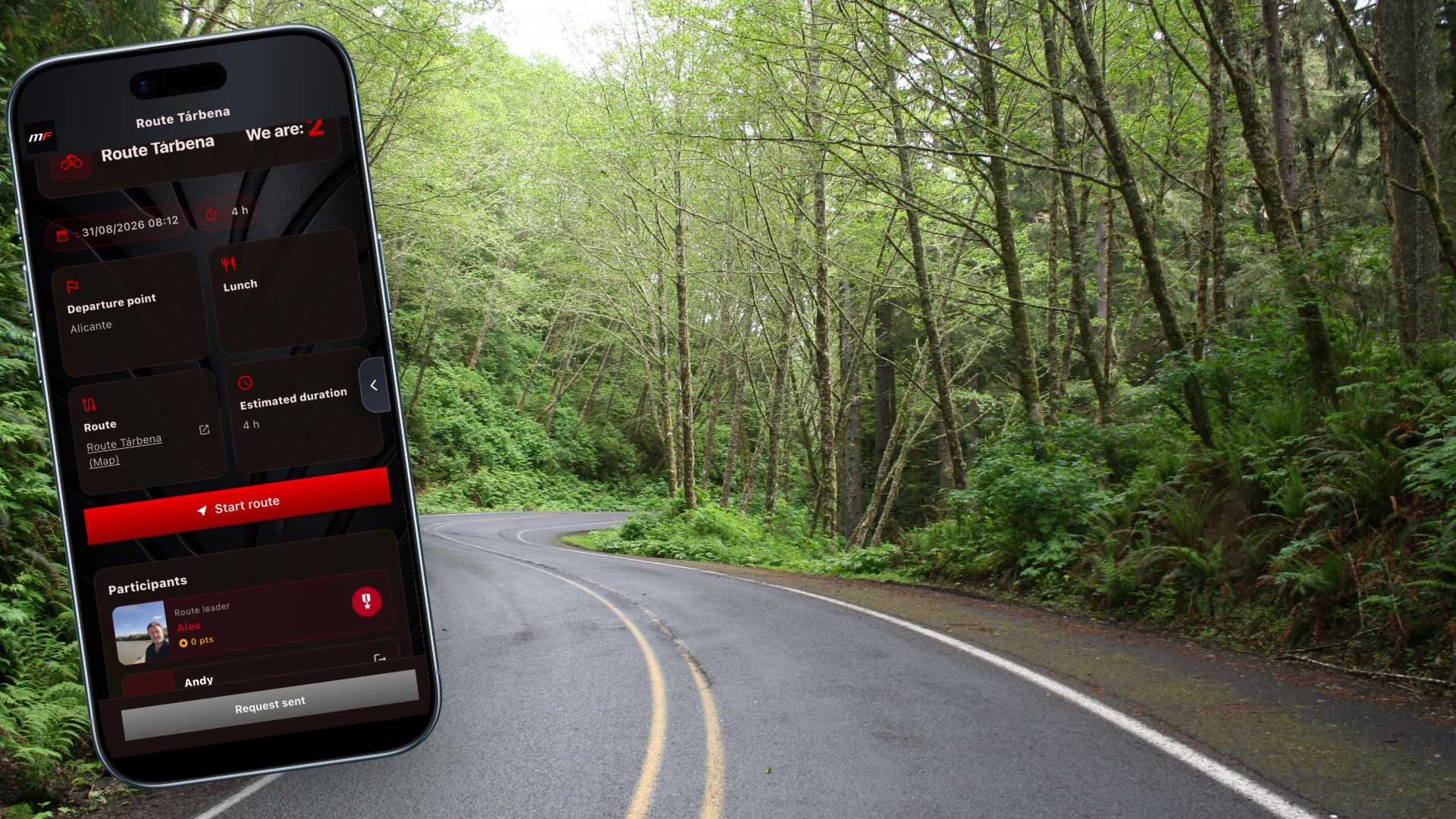
Εκδηλώσεις της ομάδας
Ζήσε τον δρόμο παρέα
Εδώ είναι που η παρέα σου ζωντανεύει. Η ενότητα Εκδηλώσεις είναι το σημείο συνάντησης της κοινότητάς σου: εκεί οργανώνονται, σχεδιάζονται και ζωντανεύουν οι βόλτες που πραγματικά μετράνε.
Τι θα βρεις εδώ
Όλες οι συναντήσεις, σε ένα μέρος
Δες με μια ματιά τις επόμενες εξορμήσεις της ομάδας σου, με ημερομηνία, ώρα, σημείο εκκίνησης και διάρκεια.
Όλες οι πληροφορίες πριν βάλεις μπρος
Σημείο εκκίνησης, συνολική απόσταση της διαδρομής, στάση για φαγητό και εκτιμώμενη διάρκεια. Ξέρεις ακριβώς πού, πότε και πόσο θα οδηγήσεις… πριν φορέσεις το κράνος.
Δήλωσε συμμετοχή με ένα άγγιγμα
Σ' αρέσει η διαδρομή; Μπες στην παρέα μέσα σε δευτερόλεπτα. Κι αν έρχεσαι με συνοδό, πρόσθεσε τους καλεσμένους σου χωρίς μπελάδες, για να μη μείνει κανείς σπίτι.
Δες ποιοι δηλώνουν συμμετοχή
Δες τη λίστα με όσους έχουν επιβεβαιώσει και τη λίστα αναμονής. Θα ξέρεις με ποιους θα οδηγήσεις πολύ πριν φτάσεις στο σημείο συνάντησης.
Για τους διαχειριστές
Δημιούργησε, επεξεργάσου και διαχειρίσου τις εκδηλώσεις της ομάδας σου. Έλεγξε τις εγγραφές, άνοιξε ή κλείσε τη λίστα συμμετοχών όποτε θες και κράτα τις εξορμήσεις σου πάντα υπό έλεγχο.
Από την οθόνη στην άσφαλτο
Κάθε εκδήλωση συνδέεται με την καθοδηγούμενη πλοήγηση βήμα προς βήμα του MotoFlap: κατευθείαν από τη λίστα στη διαδρομή, χωρίς να χάσεις ούτε μία στροφή. Και κατά τη διάρκεια της πορείας θα βλέπεις στον χάρτη πού βρίσκονται οι συνοδοιπόροι σου ανά πάσα στιγμή, ώστε το να χαθείτε να μην είναι πρόβλημα.
Χωρίς ψιλά γράμματα
Δωρεάν στ' αλήθεια. Όχι «δωρεάν μέχρι να θες να το χρησιμοποιήσεις».
Ξέρεις το κόλπο: κατεβάζεις την εφαρμογή και, μόλις πας να κάνεις κάτι ουσιαστικό, εμφανίζεται το τείχος πληρωμής. Με το MotoFlap, όχι. Επειδή έχουμε δική μας υποδομή, μπορούμε να προσφέρουμε χωρίς να πληρώνεις δεκάρα αυτά που οι άλλοι σου χρεώνουν από το πρώτο λεπτό.
Καθοδήγηση βήμα προς βήμα
Περιλαμβάνεται στη δωρεάν έκδοση. Χωρίς πληρωμή.
Android Auto και CarPlay
Περιλαμβάνονται. Πολλές εφαρμογές τα κρατάνε μόνο για τους συνδρομητές.
Εισαγωγή και εξαγωγή GPX
Περιλαμβάνεται. Οι διαδρομές σου μπαινοβγαίνουν ελεύθερα, χωρίς κλειδαριές.
Σχεδιαστής διαδρομών
Περιλαμβάνεται, με τις χαράξεις που πραγματικά θέλει ένας μοτοσικλετιστής.
Ναι, η δωρεάν έκδοση έχει τα όριά της —είμαστε μια ομάδα, όχι ΜΚΟ—. Όμως κάνει περισσότερα, δωρεάν, από πολλές εφαρμογές επί πληρωμή.
Τιμή χωρίς ανταγωνισμό
Το Pro που κοστίζει λιγότερο από έναν καφέ τον μήνα.
Αφού δεν πληρώνουμε μεσάζοντες για τους χάρτες ούτε για τις διαδρομές, δεν μετακυλίουμε αυτό το κόστος στην τσέπη σου. Περισσότερες δυνατότητες, μικρότερη τιμή. Τόσο απλά.
Free
0 €
για πάντα
Pro
17,99 €
/έτος
Δημιουργία διαδρομών
Σχεδιασμός διαδρομών
Στροφές και προφίλ δρόμου
Εισαγωγή GPX
Εξαγωγή GPX
Κυκλικές διαδρομές
Προσωπικές διαδρομές
Καταγραφή διαδρομών
Προηγμένα στατιστικά
Πλοήγηση
Καθοδηγούμενη πλοήγηση βήμα προς βήμα
Online χάρτες
Βενζινάδικα, εστιατόρια, συνεργεία και άλλα στον χάρτη
Offline χάρτες
Android Auto και Apple CarPlay
Διαχείριση ομάδας
Ιδιωτικές ομάδες
Μέλη ανά ομάδα
Εκδηλώσεις και συναντήσεις
Παρακολούθηση της ομάδας σε πραγματικό χρόνο
Ασφάλεια
Η ασφάλεια δεν θα έχει ποτέ τιμή. Όλες αυτές οι λειτουργίες, σήμερα και αύριο, είναι δωρεάν για όλους — και πάντα θα είναι.
Πολυγλωσσικό
Ειδοποιήσεις για κάμερες
Ειδοποιήσεις καιρού στη διαδρομή
Δες τους συνοδοιπόρους στον χάρτη
Μοιράσου την τοποθεσία σου με σύνδεσμο
Καθοδήγηση σε κοντινά βενζινάδικα και συνεργεία
Θα μπορούσαμε να βάλουμε πολλά περισσότερα στο MotoFlap, αλλά αν πιστεύεις ότι τα χρειάζεσαι, ίσως δεν θα έπρεπε να ανέβεις σε αυτή τη μηχανή.
ΘΥΜΗΣΟΥ: εσύ είσαι το καλύτερο σύστημα ασφαλείας. Μην κάνεις βλακείες που 100% δεν αξίζουν τον κόπο, και όλα θα πάνε καλά.
Όλες οι λειτουργίες του Free περιλαμβάνονται στο Pro. Ακύρωσε όποτε θες.
Συχνές απορίες
Συχνές ερωτήσεις
Είναι δωρεάν το MotoFlap; +
Ναι. Το πλάνο Free περιλαμβάνει τον σχεδιασμό διαδρομών, την εξαγωγή GPX και μία ιδιωτική ομάδα. Μπορείς να περάσεις στο Pro όποτε θες.
Δουλεύει χωρίς σήμα; +
Με το πλάνο Pro μπορείς να κατεβάσεις ολόκληρες περιοχές και να πλοηγείσαι με offline χάρτες, μαζί με τα σημεία ενδιαφέροντος για μοτοσικλετιστές.
Μπορώ να κάνω εξαγωγή τις διαδρομές μου σε άλλον πλοηγό; +
Όλες οι διαδρομές μπορούν να εξαχθούν σε μορφή GPX, συμβατή με τους περισσότερους πλοηγούς και εφαρμογές για μηχανές.
Είναι όντως ιδιωτικές οι ομάδες; +
Ναι. Μόνο τα μέλη που εγκρίνεις μπορούν να δουν την ομάδα, τις διαδρομές και τις συναντήσεις της. Τίποτα δεν είναι δημόσιο, εκτός αν το αποφασίσεις εσύ.
Δίκτυο πλοήγησης MotoFlap
Παγκόσμια κάλυψη, όπου κι αν οδηγείς
Η χαρτογράφηση και οι μηχανισμοί διαδρομών μας καλύπτουν Ευρώπη, Αμερική, Ασία και Αφρική. Πέρνα σύνορα χωρίς να αλλάζεις εφαρμογή και χωρίς να χάνεις τη διαδρομή σου.

4
ήπειροι σε κάλυψη
24/7
δικοί μας servers σε λειτουργία
OSM
ενημερωμένη παγκόσμια χαρτογράφηση