

Найкращі дороги,
сплановані саме для тебе.
Ми генеруємо маршрути з потрібними тобі серпантинами, ти організовуєш зустрічі зі своєю групою та їдеш із попередженнями в реальному часі. Усе в одному застосунку, створеному мотоциклістами для мотоциклістів.
Власна інженерія
Ми не орендуємо свою технологію. Ми її створюємо.
Поки інші застосунки залежать від чужих API — і перекладають цей рахунок на тебе — MotoFlap працює на власній інфраструктурі, розробленій нашою інженерною командою. Результат? Більше безкоштовних функцій і ціна поза конкуренцією.
Власний рушій маршрутів
Ми прокладаємо кожен маршрут на власних серверах, налаштованих під трасу, якої справді хоче мотоцикліст: серпантини, перевали та другорядні дороги.
Актуальні карти всього світу
Глобальні карти на основі OpenStreetMap, що зберігаються й оновлюються на нашій інфраструктурі. Без обмежень за країнами та без чужих квот.
Твої маршрути належать тобі
Ми не продаємо твою активність і не залежимо від Google. Твоя телеметрія живе в наших системах, а не в когось із рекламодавців.
Сервери в Європі
Власна високопродуктивна інфраструктура в Європі, під постійним наглядом, щоб відповідати в реальному часі, де б ти не був.
Усе в одному застосунку
Створено під те, як ти реально їздиш
Плануй, ділися й навігуй, не перестрибуючи між пʼятьма різними застосунками. Ми зібрали в MotoFlap усе, що потрібно мотоциклісту до, під час і після кожного виїзду.
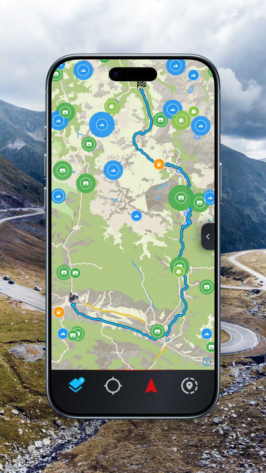
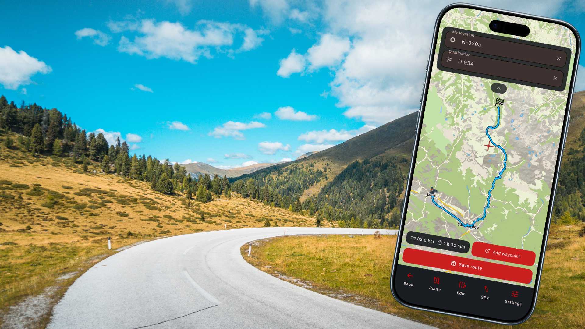
Планувальник маршрутів
Будуй оптимальні мотомаршрути за лічені секунди. Регулюй кількість поворотів, оминай автомагістралі та експортуй готовий трек у свій навігатор.
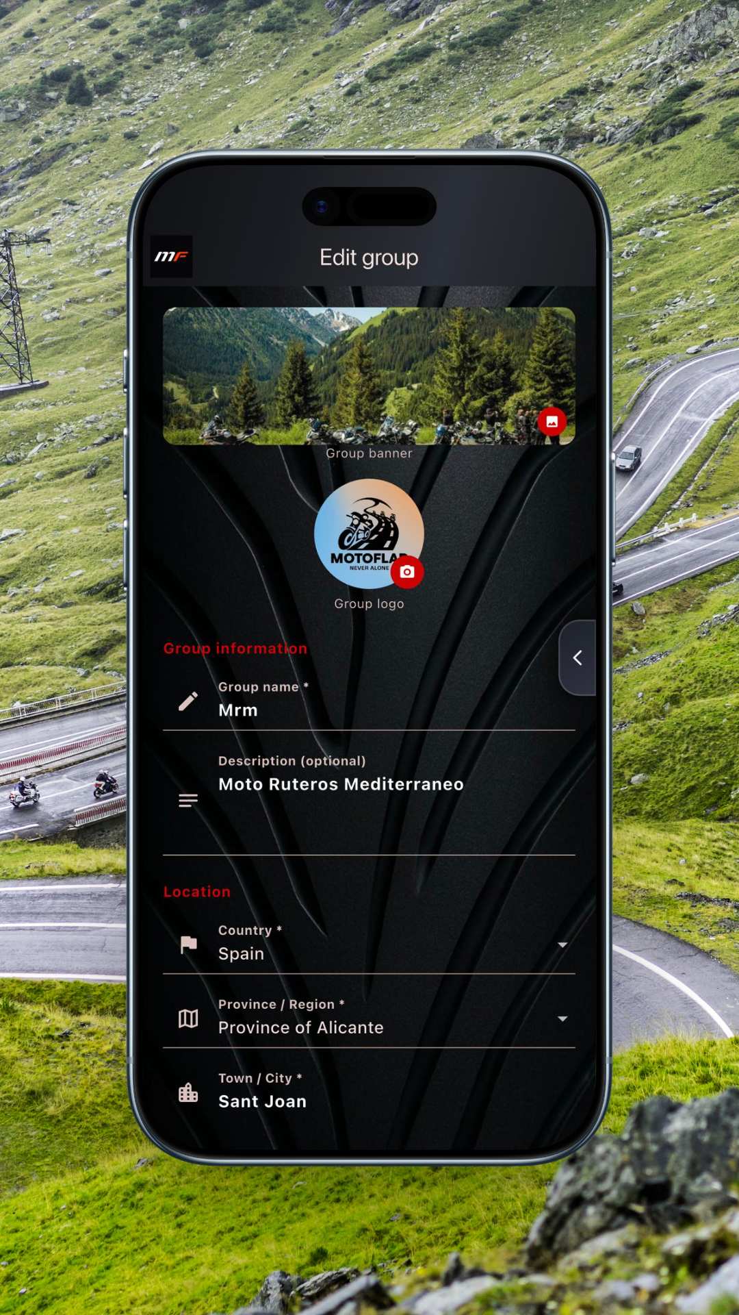
Приватні групи
Створи свій клуб чи компанію в приватній групі. Керуй учасниками, ділися маршрутами та плануй виїзди без зайвого галасу й випадкових людей.
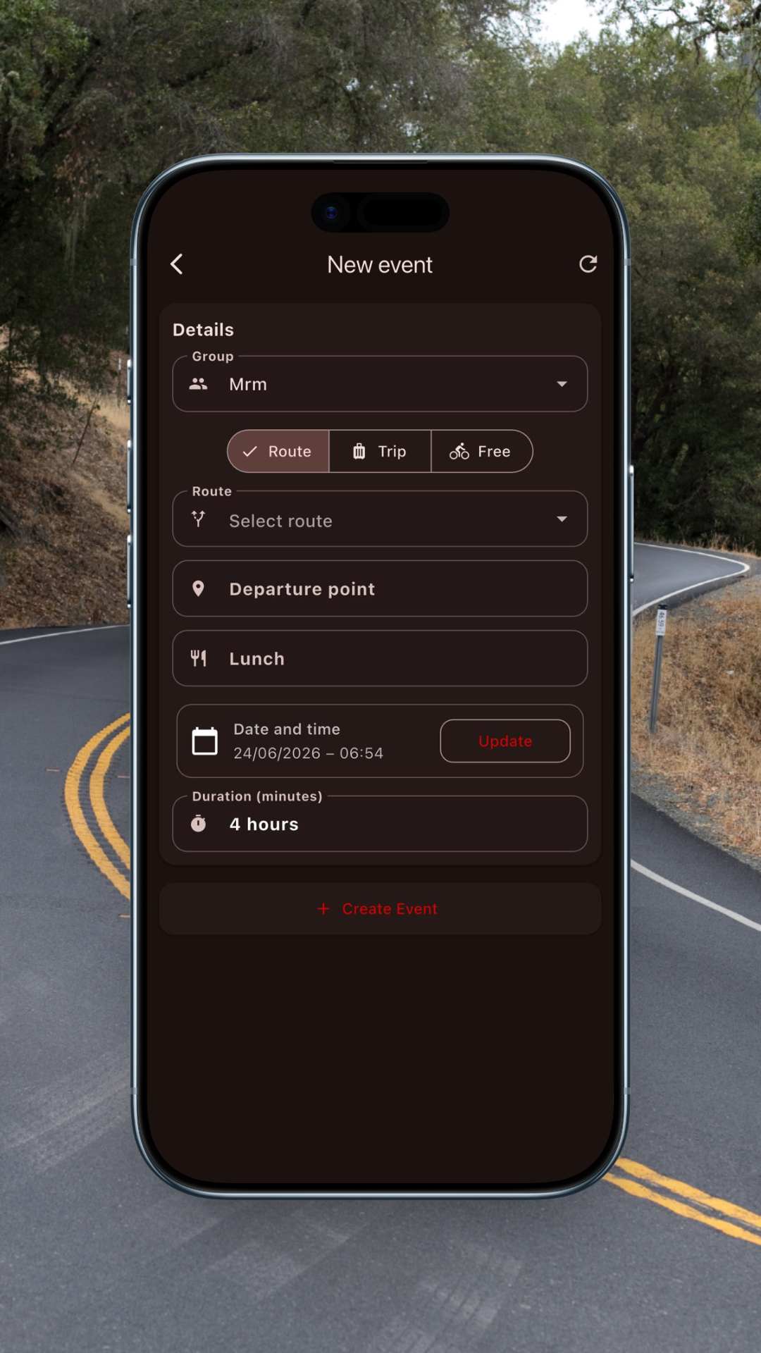
Події та зустрічі
Створюй виїзд, підтверджуй учасників і ділися точкою старту. Уся компанія знає, де й коли збиратися, — без нескінченних чатів.
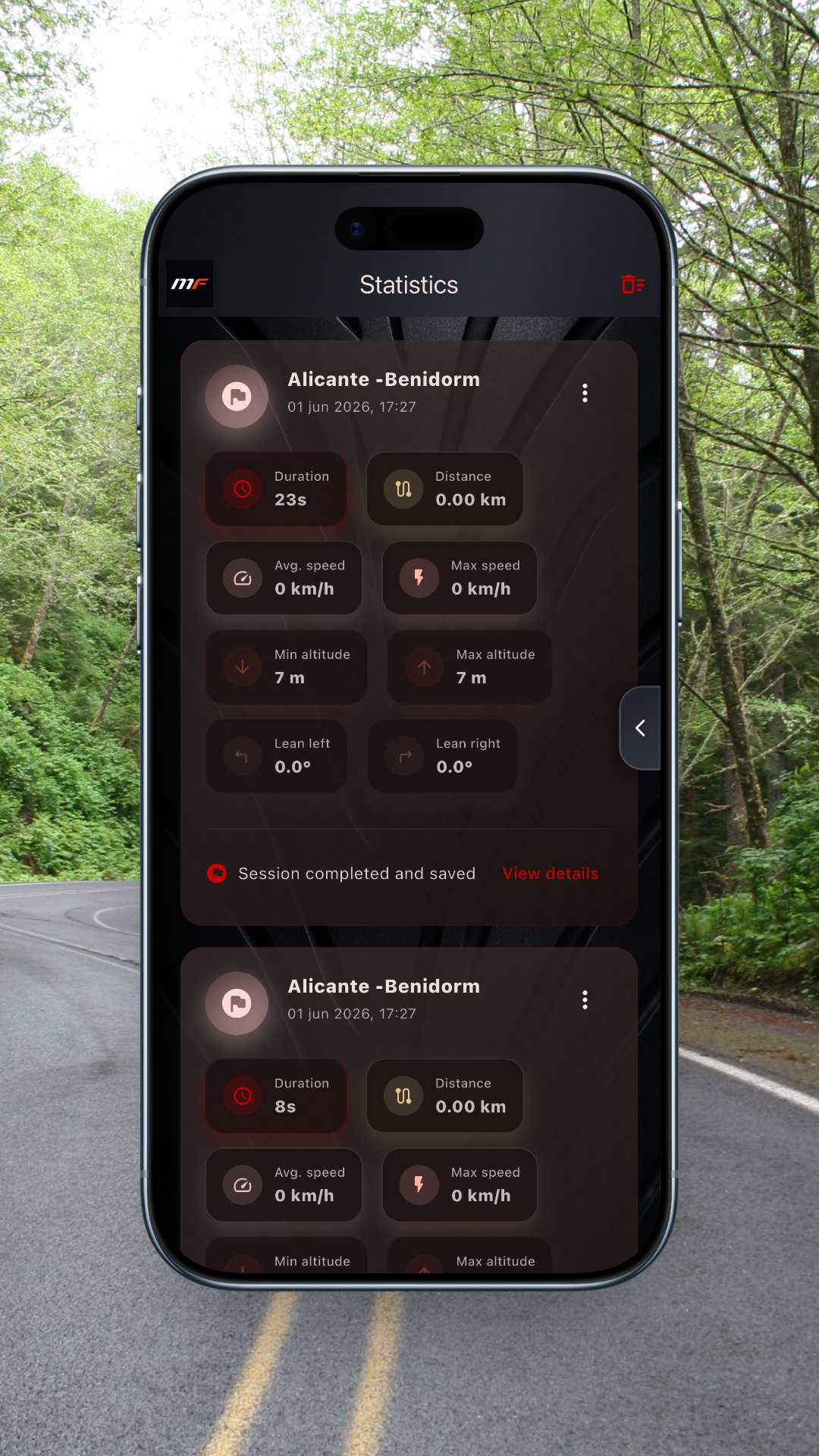
Статистика
Записуй кожен виїзд і дивись пройдені кілометри, набір висоти та кількість поворотів. Весь твій мотосезон — у цифрах.
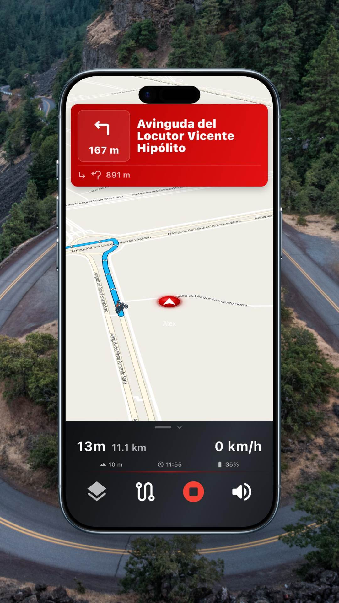
Навігація зі сповіщеннями
Їдь зі сповіщеннями про радари й погоду на маршруті. Працює з кріпленням на кермо, Android Auto і CarPlay.
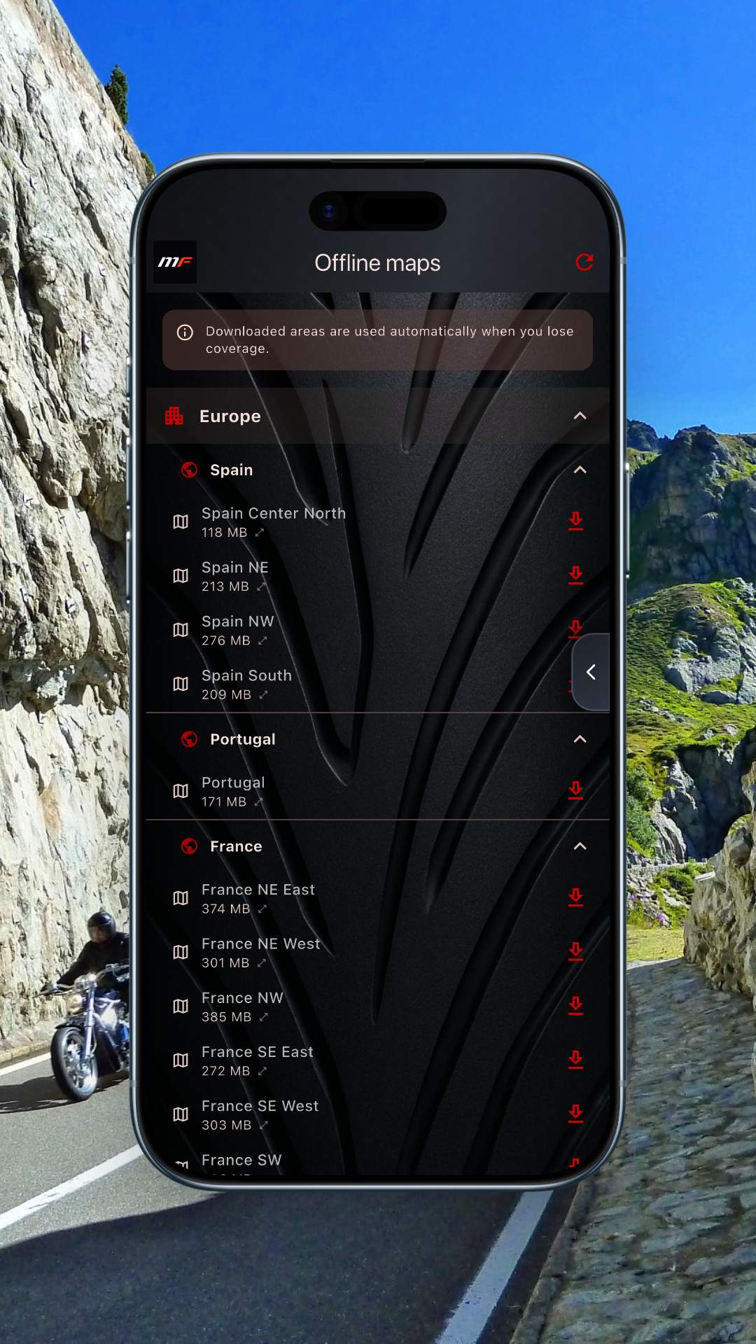
Офлайн-карти
Завантажуй цілі регіони й орієнтуйся навіть без зв'язку. Включено 11 категорій POI для мотоциклістів: заправки, перевали, оглядові майданчики, сервіси та інше.
Створено для екосистем, якими ти вже користуєшся
Навігація на екрані твого мотоцикла
MotoFlap працює з Apple CarPlay та Android Auto. Підключи телефон до панелі чи навігатора мотоцикла й стеж за маршрутом із поворотами, сповіщеннями та погодою прямо на екрані — не відриваючи рук від керма.
- Підказки на кожному повороті на великому екрані
- Попередження про радари й погоду перед очима
- Керування голосом і кнопками на кермі
Планувальник
Від двох точок до ідеального маршруту за секунди
Скажи нам, куди хочеш дістатися і скільки серпантинів тобі хочеться. Ми прокладемо трасу, якою ти справді отримаєш задоволення, а не найкоротшу. Порівнюй варіанти, налаштовуй і експортуй.
Познач старт і фініш
Введи назви міст або торкнись карти. Автозаповнення розпізнає навіть маленькі села та гірські перевали.
Обери рівень звивистості
Від прямої автомагістралі до максимуму поворотів. Планувальник віддає перевагу асфальту, від якого ти справді кайфуєш.
Перевір результат
Відстань, час, набір висоти й індекс звивистості — щоб порівняти маршрути одним поглядом.
Вирушай у дорогу
Відкрий маршрут і рушай із підказками та сповіщеннями в реальному часі.
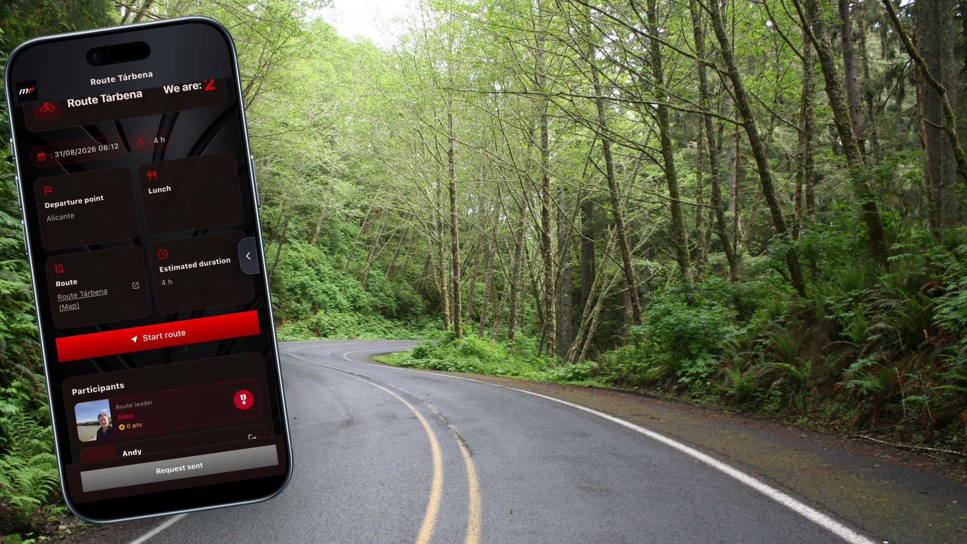
Події групи
Відчуй дорогу в компанії
Саме тут твоя група оживає. Розділ Події — це місце зустрічі твоєї мотоспільноти: тут організовують, планують і проживають виїзди, які справді важливі.
Що тебе тут чекає
Усі зустрічі — в одному місці
Дивись одним поглядом найближчі виїзди твоєї групи: дату, час, точку старту й тривалість.
Уся інформація ще до старту
Точка старту, загальна довжина маршруту, зупинка на обід і орієнтовна тривалість. Ти точно знаєш, де, коли й скільки їхатимеш ще до того, як одягнеш шолом.
Приєднуйся одним дотиком
Сподобався маршрут? Приєднуйся за лічені секунди. А якщо їдеш не сам — без зайвих клопотів додай своїх гостей, щоб ніхто не лишився вдома.
Дивись, хто їде
Переглянь список підтверджених учасників і список очікування. Ти знатимеш, з ким поїдеш, задовго до того, як дістанешся точки збору.
Для адміністраторів
Створюй, редагуй і керуй подіями своєї групи. Контролюй реєстрації, відкривай чи закривай список місць коли захочеш і тримай свої виїзди завжди під контролем.
З екрана — на асфальт
Кожна подія поєднується з покроковою навігацією MotoFlap: зі списку — одразу на маршрут, не проґавивши жодного повороту. А в дорозі ти будь-якої миті бачитимеш на карті, де твої супутники, тож загубитися більше не проблема.
Без дрібного шрифту
По-справжньому безкоштовно. А не "безкоштовно, поки не захочеш цим скористатися".
Ти знаєш цей трюк: завантажуєш застосунок, і щойно хочеш зробити щось серйозне — упираєшся в платну стіну. З MotoFlap такого немає. Завдяки власній інфраструктурі ми можемо безкоштовно віддавати те, за що інші беруть гроші з першої хвилини.
Покрокова голосова навігація
Уже в безкоштовній версії. Без жодної оплати.
Android Auto і CarPlay
Входять у комплект. Багато застосунків відкривають їх лише за гроші.
Імпорт та експорт GPX
Уже є. Твої маршрути вільно заходять і виходять, без жодних замків.
Планувальник маршрутів
Уже є, із трасами, яких справді хоче мотоцикліст.
Так, у безкоштовної версії є свої межі — ми команда, а не благодійний фонд. Але вона безкоштовно вміє більше, ніж чимало платних застосунків.
Ціна поза конкуренцією
Pro, що коштує менше за чашку кави на місяць.
Ми не платимо посередникам ані за карти, ані за маршрути — тож і не перекладаємо ці витрати на твій гаманець. Більше можливостей, менша ціна. Усе просто.
Free
0 €
назавжди
Pro
17,99 €
/рік
Побудова маршрутів
Планувальник маршрутів
Повороти й профіль дороги
Імпорт GPX
Експорт GPX
Кільцеві маршрути
Особисті маршрути
Запис маршрутів
Розширена статистика
Навігація
Покрокова навігація
Онлайн-карти
Заправки, ресторани, сервіси та інше на карті
Офлайн-карти
Android Auto та Apple CarPlay
Керування групою
Приватні групи
Учасників у групі
Події та зустрічі
Відстеження групи наживо
Безпека
Безпека ніколи не матиме ціни. Усі ці функції — сьогодні й завтра — безкоштовні для всіх. І завжди такими залишаться.
Кілька мов
Попередження про радари
Сповіщення про погоду на маршруті
Бачити супутників на карті
Поділитися локацією за посиланням
Маршрут до найближчих заправок і сервісів
Ми могли б напхати в MotoFlap значно більше, але якщо тобі здається, що це потрібно, можливо, тобі не варто сідати на цей мотоцикл.
ПАМ’ЯТАЙ: найкраща система безпеки — це ти сам. Не роби дурниць, які на 100 % того не варті, і все буде добре.
Усі функції Free входять у Pro. Скасувати можна будь-коли.
Часті запитання
Поширені запитання
MotoFlap безкоштовний? +
Так. Тариф Free включає планувальник маршрутів, експорт у GPX і одну приватну групу. Перейти на Pro можна будь-коли.
Чи працює без зв'язку? +
З тарифом Pro ти можеш завантажувати цілі регіони й орієнтуватися по офлайн-картах разом із точками інтересу для мотоциклістів.
Чи можу я експортувати маршрути в інший навігатор? +
Усі маршрути можна експортувати у форматі GPX, який підтримує більшість навігаторів і мотозастосунків.
Чи справді групи приватні? +
Так. Лише ті учасники, яких ти схвалиш, бачитимуть групу, її маршрути та зустрічі. Нічого не стає публічним без твоєї згоди.
Навігаційна мережа MotoFlap
Глобальне покриття, де б ти не їхав
Наші карти та рушії маршрутів охоплюють Європу, Америку, Азію й Африку. Перетинай кордони, не змінюючи застосунок і не втрачаючи маршрут.

4
охоплені континенти
24/7
активні власні сервери
OSM
актуальні карти всього світу